Panhandle Playas and the Ogallala Aquifer
Wednesday, August 2nd, 2017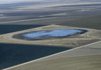
Playas are the most direct route for water to reach the Ogallala Aquifer.

This is Passport to Texas
A playa lake is a natural landscape feature of the vast, flat expanse of the Great Plains and Texas High Plains.
Really, what it is, is a low spot where rainwater collects.
More than a mere low spot, Texas Parks and Wildlife biologist Don Kahl says Texas playas are ephemeral wetlands, and vital recharge points for the Ogallala Aquifer.
They’re really the most direct link between rainwater or rainfall to the Ogallala Aquifer below. The amount of water going into the aquifer is from 10 to 100 times greater in a playa basin as compared to surrounding soils or surrounding upland areas.
Kahl calls playas “self-contained watersheds”, each playa is the center collection point of runoff from surrounding uplands. Most playas only exist for a brief time after it rains. Clay soil lines the bottoms of these shallow basins permitting the rainwater and runoff to collect and slowly filter into the aquifer below.
In combination with a healthy playa, having a grass buffer around it helps to filter out sediments and some of the contaminants running off of neighboring fields. You also get a secondary cleaning with the clay layer in the basin, helping to filter out other contaminants and nitrates as the water passes down into the aquifer.
Recharge rates are slow, and it takes years for rainwater to pass from playas, through soil, and into the aquifer.
The Wildlife and Sportfish Restoration program supports our series and funds diverse conservation projects throughout Texas.
That’s our show for today… For Texas Parks and Wildlife…I’m Cecilia Nasti

 Passport to Texas is a