Spring Break: Wildlife Trail Maps & Migration
Friday, March 4th, 2016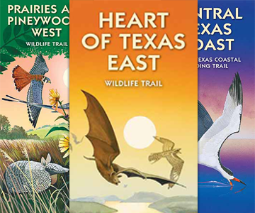
Wildlife Trails Maps from Texas Parks and Wildlife, available for purchase or free digital download.

This is Passport to Texas
Beginning in February and continuing through May, birders watch the sky for spring migrants.
Texas is unique in that it has a great funnel of flyways. Spring migration is a great time to go and experience all the different birds that come through Texas.
Liz Tomberlin works in Nature Tourism at Texas Parks and Wildlife. From casual birders to listers, these maps have something for everyone! There are well-known sites such as High Island as well as lesser-known local gems and private ranches. To find the road less traveled—grab a Wildlife Trail map.
And what our Wildlife Trail maps do is give them more of an individual experience and give them places that might be hidden gems in the community where they can go and avoid the crowds and see all the birds in a different spot that’s not so well known.
Which of the nine illustrated maps would Liz suggest?
Definitely upper Texas coast, central Texas Coast, and Lower Texas Coast, are some of the best places to see the spring migrants. Will these maps also tell people what birds to look out for? Yes, it does! Each site description tells you different times when you can see these birds, what you can expect to see at the site, and where to go to actually view them. It’s a great tool to have if you want to come and see the spring migration.
Download free digital versions of the maps from the Texas Parks and Wildlife website; hard copies may be purchased. Find information at the TPW website.
That’s our show… For Texas Parks and Wildlife…I’m Cecilia Nasti.


 Passport to Texas is a