July 21st, 2016
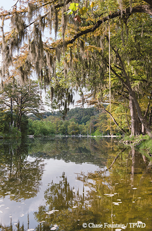
A healthy river and riparian zone.
This is Passport to Texas
We call the land that flanks rivers and streams a riparian zone. When these areas are intact with native vegetation, they slow the forces of floodwaters, help capture sediment, filter nutrients, and slow runoff from upland sources. Yet, land use practices over the past 150 years have altered their natural state.
Things like mowing, excessive foot or vehicle traffic, or excessive browsing from either livestock or unmanaged wildlife…
Ryan McGillicuddy is a Texas Parks and Wildlife conservation ecologist.
So, water sheds off quicker, it can contribute to higher peak flows for flooding. And really, those areas become less resilient; they recover less quickly from disturbance events like floods.
Floodwater, can demolish stream and river banks that lack healthy stands of native vegetation.
What happens when you reduce the vegetation diversity and number of species is you lose some of the root stock that these native trees and grasses provide. These native species have very, very deep root systems that act like rebar holding the soil together. So they’re less resistant to erosional forces. So, we end up seeing less stable stream systems.
Helping the land recover after a devastating flood event. That’s tomorrow.
The Wildlife and Sport Fish Restoration program supports our series.
For Texas Parks and Wildlife, I’m Cecilia Nasti.
Posted in Conservation, Flooding, riparian zone | Comments Off on The Reality of Weak Riparian Zones
July 20th, 2016
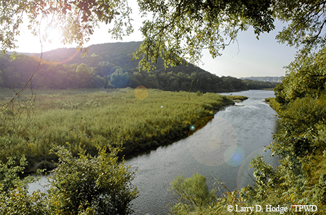
Brazos River. Image credit: Larry Hodge
This is Passport to Texas
A riparian zone is a transitional area between a stream or river and an upland ecosystem. Conservation ecologist, Ryan McGillicuddy says these strips of land, which can be from 25 to over 200 feet wide, perform vital ecological functions.
They provide excellent habitat for fish and wildlife both in stream and on the land. The leaf litter provides nutrient contributions. The fallen logs provide structural habitat in the stream for fish and wildlife. A lot of the nutrient and diet for some of our sport fish species and the food web within the channel comes from a land source. Structurally, riparian zones provide a number of functions. The plant roots act like rebar and hold the banks of the channel together to resist the force of erosion.
When rain events cause streams and rivers to overflow their banks, riparian zones are the first line of defense.
If you have an intact, healthy riparian zone, it will slow the forces of floodwaters. It will help capture sediment, filter nutrients, slow runoff from upland sources…
These healthy riparian zones also soak up water like a sponge, adding to stream flow during drier times.
Unfortunately, a lot of the land use practices over the last 150 years from really intense settlement have altered the natural state of some of these riparian zones.
Tomorrow: When riparian zones are weakened.
The Wildlife and Sport Fish Restoration program supports our series.
For Texas Parks and Wildlife, I’m Cecilia Nasti.
Posted in Conservation, Flooding, riparian zone | Comments Off on Benefits of Healthy Riparian Zones
July 19th, 2016
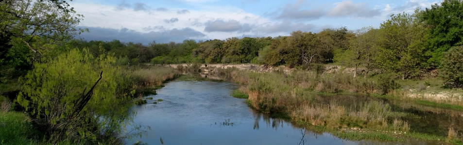
South Llano River
This is Passport to Texas
The technical name for the land along river and stream banks is riparian zone.
A riparian zone is that special transition zone between the stream channel and the uplands.
Ryan McGillicuddy, a conservation ecologist with Texas Parks and Wildlife, says riparian zones are diverse.
It’s comprised of different composition of plant species, and it’s critical to the health of both the channel and the uplands. So, it’s a narrow band, but it’s really important in the health and function of a stream and for fish and wildlife habitat.
Depending on the size of the river or stream, a riparian zone can be from 25 to over 200 feet wide. Identifying where the riparian zone ends and the uplands begins isn’t as hard as you might imagine.
It’s basically that area on the slope, coming up away from the channel, until you see things that are more typical of upland vegetation. In the Hill Country, that would be when you start seeing things like cedar and ash juniper.
These strips of land are more than places to bring a picnic or fishing pole.
Riparian zones perform a number of ecological functions, as well as structural functions in protecting streams and keeping them—I guess—resisting forces like erosion.
And we’ll learn more about that tomorrow.
The Wildlife and Sport Fish Restoration Program supports our series.
For Texas Parks and Wildlife, I’m Cecilia Nasti.
Posted in Conservation, Flooding, riparian zone | Comments Off on Riparian Zones: Life Along the Edges
July 18th, 2016
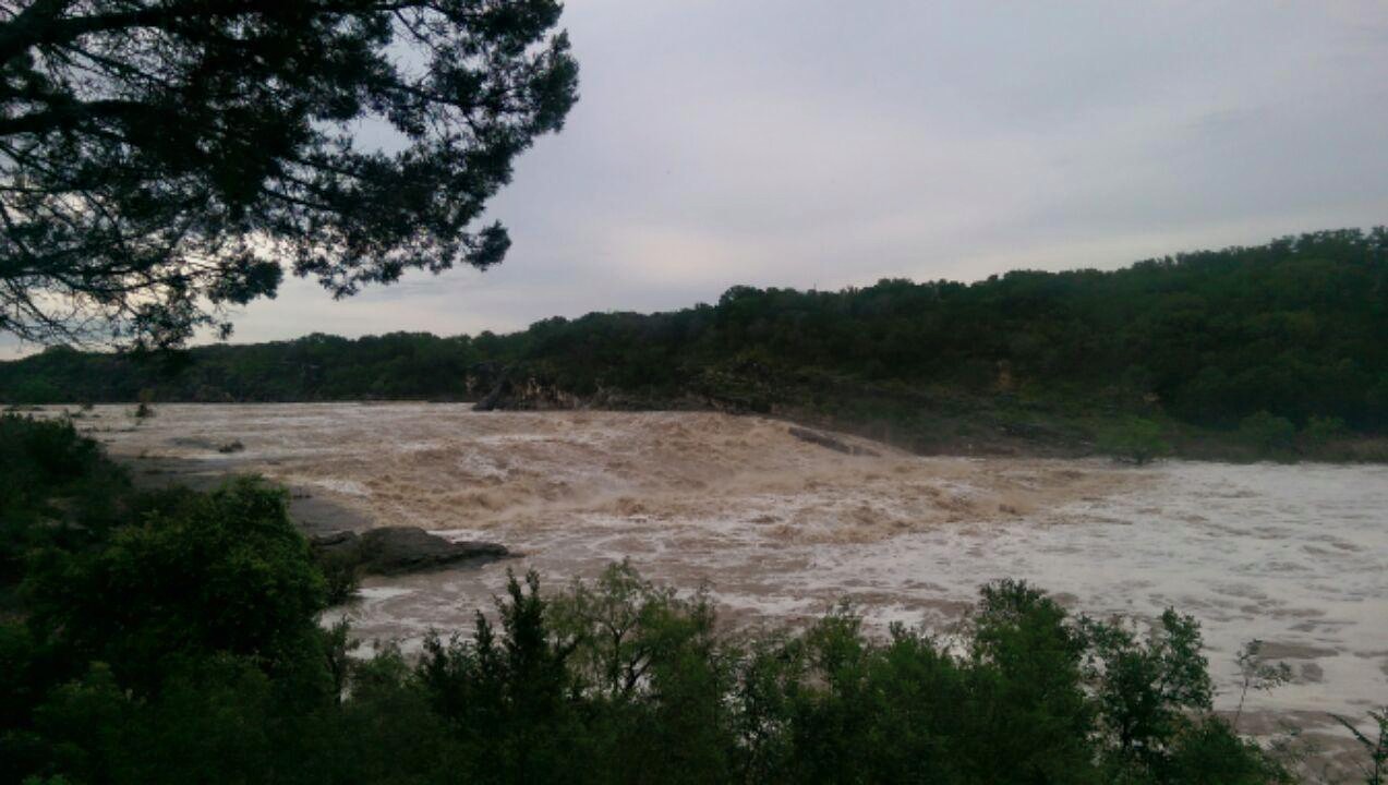
Pedernales Falls State Park Flood May 24 2015
© Texas Parks and Wildlife Department
This is Passport to Texas
Torrential rains in 2015 and again in 2016 ended five years of exceptional drought across Texas, but also caused rivers to flood.
It’s important to recognize that floods are a part of a functioning river system.
Ryan McGillicuddy is a Texas Parks and Wildlife conservation ecologist. We tend to focus on the negative impacts of flooding, but ecologically, floods have beneficial functions, too.
Once the water spills out of its normal channel, it infiltrates into that riparian zone, and becomes absorbed by that soil and then acts as a time-release capsule that feeds the river channel; the water makes its way back to the channel in the drier times of the year. There are also a number of fish and animal species that are dependent on floodwaters. There are a number of tree species that thrive on floodwaters. So, ecologically, there are a number of things a functioning floodplains provide.
A riparian zone is the land that parallels rivers and streams. A broad and wide undeveloped floodplain contains plenty of vegetation that forces floodwaters to slow down, giving soil time to absorb them, thus protecting more developed areas downstream.
It gives water a place to go.
Getting to know riparian zones…that’s tomorrow.
The Wildlife and Sport Fish Restoration program supports our series.
For Texas Parks and Wildlife, I’m Cecilia Nasti.
Posted in Conservation, Flooding | Comments Off on The Benefits of Flooding
July 15th, 2016
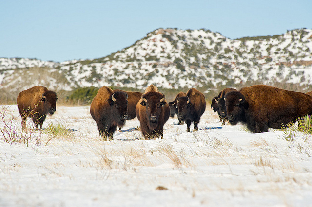
Bison at Caprock Canyons State Park
This is Passport to Texas
For the past 30 years, PBS viewers have experienced the Texas outdoors through Texas Parks and Wildlife’s television series. To celebrate, show producers, including Karen Loke who’s been with the series 24 years, share their favorite stories from the past.
And my favorite story is called Rescuing History. It’s about the capture and relocation of the last of the Southern Plains bison herd.
[Narrator Jim Swift] Doug is helping capture and relocate the last few descendants of the Southern Plains Bison. A pure, genetic strain of buffalo found nowhere else in the world.
[Doug Humphreys] But what makes this one different is that another buffalo has never been brought into this herd. There’s been no outside gene source introduced into this particular bison herd. So we’ve got a distinct genetic strain of buffalo that doesn’t exist anywhere else.
Producer Karen Loke said this touched her due to something rather unexpected that happened during filming. You can see for yourself when you tune into the Texas Parks and Wildlife television series on PBS the week of July 17.
[Roy Welch] To those of us involved in this project, it’s turned into be something quite more than just a simple matter of capturing a bison herd and relocating them over here to Caprock Canyons, in essence, we’re literally capturing a living piece of Texas history.
The award-winning Texas Parks and Wildlife Television series celebrates 30 years on PBS all season long. Check your local listings.
For Texas Parks and Wildlife, I’m Cecilia Nasti.
Posted in History, State Parks, TPWD TV, Wildlife | Comments Off on TPW TV – Rescuing History


 Passport to Texas is a